About Us
About the Sulphur River Basin Authority
About SRBA
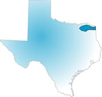 The Sulphur River Basin is in the northeast corner of Texas.
The basin includes all or part of Fannin, Hunt, Lamar, Hopkins,
Red River, Franklin, Titus, Morris, Bowie, Cass and Delta counties.
The headwater streams are the North and South Sulphur Rivers.
These rivers originate in Fannin County. The Middle Sulphur converges
with the South Sulphur at Cooper Lake. These rivers all converge and
flow eastward into Wright Patman Lake and exit Texas south of the city
of Texarkana. The Sulphur River Basin drainage area is approximately
3,558 square miles.
The Sulphur River Basin is in the northeast corner of Texas.
The basin includes all or part of Fannin, Hunt, Lamar, Hopkins,
Red River, Franklin, Titus, Morris, Bowie, Cass and Delta counties.
The headwater streams are the North and South Sulphur Rivers.
These rivers originate in Fannin County. The Middle Sulphur converges
with the South Sulphur at Cooper Lake. These rivers all converge and
flow eastward into Wright Patman Lake and exit Texas south of the city
of Texarkana. The Sulphur River Basin drainage area is approximately
3,558 square miles.
Our web site is intended to be a place where the public can access information about the Authority and the Sulphur River Basin. This site will also provide updates on various projects being undertaken throughout the basin, and serve as a forum for the public to provide input.
The Sulphur River Basin is in the northeast corner of Texas. The basin includes all or part of Fannin, Hunt, Lamar, Hopkins, Red River, Franklin, Titus, Morris, Bowie, Cass and Delta counties.
Contact Info
Sulphur River Basin Authority (SRBA)
115 W. 1st
Suite # 102
Mount Pleasant, TX 75455
Phone: (903) 223-7887
Fax: (903) 223-7988
SRBA © 2015-2021
This website is maintained by
Integrated-Data Services